Our National Park is getting bigger!
Yesterday the boundary changes were announced for the Lake District and Yorkshire Dales National Parks by way of a formal notice of confirmation (Adobe/PDF, 75KB). Essentially this extends both national parks towards each other separated by the M6. You can view all the details maps here on the Government publication page but here's our executive summary.
Lake District National Park
The changes to the Lake District National Park are actually relatively small, increasing its total land area by 3%. Here's a grab of the overview map (Adobe/PDF, 955KB):
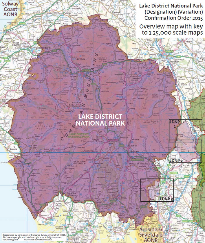
 And here is our blow up of the key areas. If you want to see the three maps in detail then LDNP 1 (Adobe/PDF, 1.0MB), LDNP 2 (Adobe/PDF, 997KB), and LDNP 3 (Adobe/PDF, 1.1MB) are all available to download.
As you can see there are essentially two areas being added:
- a larger area along both sides of Borrowdale right up to the M6 taking in Birkbeck Fells Common, Bretherdale, Bretherdale Bank, Bretherdale Common, and Roundthwaite Common on the northern side and Whinfell Common and Greyrigg Forest to the south.
This bring a number of new tops into the national park: Thorny Bank, Pipers Hill, Whinash, Ashstead Fell, Jeffrey's Mount, Mabbin Crag, Castle Fell, Whinfell Beacon, and Grayrigg Forest. Most of these are Tumps but Mabbin Crag is a sub HuMP and Grayrigg Forest is also a Marilyn.
- A smaller area south west of Kendal centred on Sizergh Castle and bounded on the east by the A591 southern feeder road into the Lakes from the M6.
This is flatter land and brings in just one new top: Sizergh Fell which is a Tump.
Yorkshire Dales National Park
If anything the changes to the Yorkshire Dales National Park are the more significant, increasing its total land area by nearly 24%. Again here's a grab of the overview map (Adobe/PDF, 1.5MB) (to see the details maps you need to visit this page):

As you can see it pushes the national park significantly to the north west into the area bounded to the west by the M6 and the north east by the A66 and there's also expansion to the west towards the M6 bounded at the bottom by ther A65.
If you're thinking to yourself "doesn't this mean that some of the Yorkshire Dales National Park is now going to be in Cumbria?" yes it does, but this was already true: Sedburgh for example lies in the existing Yorkshire Dales National Park but is part of the modern county of Cumbria1.
So the Yorkshire of the the Yorkshire Dales National Park is not the same as the civil county, but then it wasn't before.
We've not yet sat down and worked out what tops will now fall into the Yorkshire Dales National Park but we imagine it will be quite a few and no doubt our next hill database update will reflect that.
Our Opinion
We've been in favour of this proposal right from the start as designating an area as a National Park both helps protects it from unsightly and inappropriate development and attracts more people to come and discover what's there which is both good for the local economy and in turn takes pressure off the existing land in the National Parks.
You can comment on this post in our forum.
Participants in these activities should be aware of and accept these risks and be responsible for their own actions.