WalkLakes Blog
2024 | |||
| July | |||
| A Busy Weekend | |||
| June | |||
| Going camping? Make sure you're safe | |||
| April | |||
| Herdy supports sheep safety this spring | |||
| March | |||
| Piers Gill. Something has changed. | |||
| February | |||
| Using our Mapping for Other Walks | |||
2023 | |||
| November | |||
| Winter - Time to check your gear | |||
| September | |||
| Hills Database Updated | |||
| August | |||
| Being Prepared | |||
| July | |||
| Leave Only Pawprints | |||
| June | |||
| Mountain Rescue Box ransacked | |||
| May | |||
| A Happy Lake District Story | |||
| April | |||
| Lost in the Lakes | |||
| Wasdale MRT Open Day | |||
| No More Accommodation Adverts | |||
|
23/07/24
• A Busy Weekend
A brief report from the Lake District Search And Mountain Rescue Association on an unprecedentedly busy weekend.
Last weekend was an unprecedentedly busy one for LDSAMRA, as the Summer holidays started for many across the UK, with multiple deployments from 9 of their 12 teams, Helimed 58, Coastguard 199 & RAF Leeming. read more ... |
|
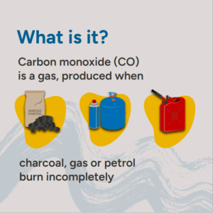
20/06/24
• Going camping? Make sure you're safe
When you're camping carbon monoxide (CO) is a gas that you can't see, hear or taste. But it can kill.
|
|
03/04/24
• Herdy supports sheep safety this spring
The iconic Cumbrian brand Herdy has teamed up with Cumbria Constabulary, Lake District National Park Authority, National Farmers Union (NFU), and the National Trust to raise awareness of the importance of keeping dogs on leads to protect sheep. especially in the lambing season.
The iconic Cumbrian brand Herdy has teamed up with Cumbria Constabulary, Lake District National Park Authority, National Farmers Union (NFU), and the National Trust to raise awareness of the importance of keeping dogs on leads to protect sheep, especially in the lambing season. A colourful poster featuring the iconic Lake District character has been launched as a reminder. read more ... |
|
19/03/24
• Piers Gill. Something has changed.
A guest post by Wasdale Mountain Rescue Team about a sudden series of incidents at Piers Gill coming off Scafell Pike.
What follows is a guest post by the Wasdale Mountain Rescue Team who are asking that this message be shared far and wide so please do share and re-post. read more ... |
|
02/02/24
• Using our Mapping for Other Walks
Here at WalkLakes we have two obsessions: walking and mapping and here's an example of our mapping being used by other people to create great walks.
Here at WalkLakes we have two obsessions: walking and mapping. So as well as finding you the best Lake District walks we also illustrate them using our our mapping, which we call WayMaps, and you see that used both in our walks and our GPS Mapping app. read more ... |
|
16/11/23
• Winter - Time to check your gear
Time to wash, proof and otherwise prepare your existing winter gear; and new gear you might want to buy
With autumn upon us, the fells are going brown as flora and fauna prepare to sleep through the harshness of winter. This is a great time to be out on the fells, there's a quiet solitude awaiting those who do. Especially away from the popular areas you may go all day without seeing anyone else. read more ... |
Participants in these activities should be aware of and accept these risks and be responsible for their own actions.